Showing posts with label Bridge. Show all posts

Monday, May 13, 2024

Slippery Tracks


My Alexa “home assistant” was flashing with a yellow circle this morning which means I either have a delivery from Amazon or there is a weather warning. “Alexa, what are my notification?” Produced a weather advisory of a frost warning for back home in Dartmouth: here in Toronto the forecast was for record high temperatures of over 24ºC. Sounded like a good day for an outing to explore another page of my “111 Things not to be missed in Toronto” book. 


This time I elected to go visit the Humber River Arch Bridge in the west end of the city on the Lake Ontario waterfront in the suburb of Etobicoke. Similar to the lovely bridges I visited on the Toronto Portlands, this bridge is an arched design but is a pedestrian and cyclist bridge which spans the mouth of the Humber River where it flows into Lake Ontario. 

Another Labyrinth to walk 


The bridge is about 15 km from the condo, so we knew we would have to take public transit. I looked at options and decided on a route involving a walk, then a subway trip, a streetcar ride and then a walk along the waterfront to the bridge. Unfortunately this was the day that TTC (Toronto Transit Corporation) who I have been bragging about, finally let me down. After walking from the condo up to Subway Line 2 on Bloor St. The crowds of people standing outside the subway station suggested something was not working as smoothly as usual. Apparently one of the subway trains had deposited gallons of hydraulic oil all over the tracks under the trains. Steel wheels, steel tracks, liberal coat of slippery oil . . . . the trains were sliding right through the stations, unable to stop. A whole section of the line was closed for the day while the mess was cleaned up. There were shuttle buses available but the crowds of people waiting to use them discouraged us from this option. 

Does it mean "Go turtle speed" on bridge?


A discussion with a TTC employee told us that a walk of four or five blocks allowed us to rejoin the subway and head west on the section not affected by the oil spill. Fortunately, being retired, we were only going out exploring the city, not going to work and keeping the economy going as were the people waiting for the shuttle buses and we did not mind the walking detour. And the rest of the transit trip worked perfectly. 


We managed to find the bridge and walk over it, take lots of photos, explore a new section of the Toronto waterfront parks, walk another labyrinth, see the Toronto Skyline from a completely different viewpoint, find a pub with a lovely view out over Lake Ontario for drinks and lunch, and I can note another page of the 111 that we have visited.  

This is the bridge . . .

Stop to lookout over Toronto

A different view of Toronto

It really is a nice bridge . . .

And . . . time for a beer and lunch


Tuesday, February 20, 2024

NS Bridges and Man-made Rivers

The planned Portlands

In October, we went down to have a look at the new “built in Nova Scotia” bridges being installed in the Toronto Portlands and although we did get to walk across one of the bridges, we were disappointed to find that the other two were not open yet. That trip did inspire me to do some research on this area of the city and I discovered that there is a very ambitious plan to revitalize the area to convert what is now an industrial wasteland with deflect building and piles of dirt into parkland and prime real estate. During our October walk (see the post called “Caution Construction”) we had a difficult time even walking the area, so when I saw a news article about the now “open”bridges and the new “artificial river”, I decided it was time to go back for another look. 
What it looks like now


As we got to the waterfront, you could see that the road leading to the first bridge, a double span with lanes for bicycles, vehicles and pedestrians was finally open and clear. Now I say open, but really only one span was actually operational so us walkers had to share with bicycles, but we were able to walk across the bridge and onto the Portlands. There was still a lot of construction going on, and we did have to avoid excavators and dump trucks, but although landscaping still has to be completed, you could see clearly what this would look like when finished, and it should be very nice.

Built in Nova Scotia


Once across the bridge, we could continue on across the bridge we previously explored on into the actual working Portlands, or we could walk down a new wide avenue to the fourth bridge which crossed the “Artificial River”. Having done the other bridge, we chose to walk down to the one we had not visited. The road across this bridge continued down along the waterfront into another industrial area, but the bridge crossed a man-made river which winds through the Portlands and will eventually connect the Don River wth Lake Ontario, allowing it to flow peacefully through a newly designed recreational park rather than just dumping into the mostly unused Keating ship channel. 


These four bridges and the artificial river are just the first part of an ambitious 1.3 billion flood protection and revitalization project for the Portlands. There will be a section of the project that will be used for more Toronto High Rise Condos and a large section will be landscaped and reforested into a beautiful recreational area. As we walked across the fourth bridge, we could see the work being done in the area and it is easy to imagine what it will look like when finished. The “river” has water in it, but is not yet connected with the real river and many little trees already line its banks. 

The River Ends Here for Now


Now those proposed condos will be in an amazing prime location, so I can only imagine they will become very popular locations and I am sure they will be very pricey, as they will have beautiful views, parkland next door, and are still right downtown Toronto. I wonder what they will cost?


The Ship Canal

Toronto from the new bridge

Those dirt piles will one day be condos

The Bridge and the River

This will be recreational parkland when finished


Monday, October 23, 2023

Caution . . . Construction

Beautiful new bridges

Today was a cold day, but a sunny one, so we decided to continue our waterfront walk. My goal was to go down to the western end of the downtown Toronto waterfront and try to see the new bridges that had been built in Nova Scotia to be installed here to provide better, more attractive access to the Toronto Port Lands. The area itself is actually a bit of a mess with empty lots, heavy industrial, aging grain elevators and piles of “stuff”, mixed with a yacht club and a nice beach park at the end of the road. There is an actual marine port with access for seaway freighters as well as cruise ships, but coming from Halifax with one of the best harbours on the east coast, Toronto’s Port Lands do not look that impressive. 


Walking the new bridge
There are four of the new bridges being installed but only one is actually installed and being used, while the other three are seriously under construction. Once done, these new bridges will take this rough Industrial area much more attractive, and I assume encourage some more attractive development of the underused areas of the Port Lands. These bridges are elegant attractive structures, providing a vehicle roadway, a two lane bikeway, and a nice wide pedestrian walkway. The bridges are painted white on the exterior and each is a different colour on the inside. They will be a big improvement over the narrow temporary bridge and the old rusty lift bridge. But Really . . . what do you expect from a Nova Scotia product? 


Oh, and there was lots of construction . . . . 


One of many detours

Our walk to explore this section of Toronto’s waterfront was not easy. Once finished the new bridges with provide a nice direct route, but we had to walk around a large parking lot, across a thin rubber track across a narrow bridge which we had to share with vehicle traffic, then back and forth via construction detours, closed sidewalks and roadblocks. The rusty lift bridge only supports one lane of traffic and the pedestrian walkway is a temporary wooden one that replaced a rusted metal lane. Information on Wikipedia says that the lift bridge is historically significant and is being restored and rebuilt, but it looks pretty bad right now. 
Caution


Fortunately we survived our walk through the construction zones and continued our walk to Cherry Beach where the road ends at an attractive city park. On the way I can provide an update on an earlier post about the “sea can” market. We walked by a business that promises to provide a converted shipping container for any purpose - perhaps that is where all the ones used for the market came from. I think I recognize the shipping container washrooms . . .


And then we had retrace the route and do it all over again to get home.


Toronto Beach Sand - construction debris

Need a shipping container?

"Sea Can" Washrooms ready to go

Toronto . . . not a skyscraper in sight

The lifeguard is not on duty

The CN Tower hiding behind a pile of mud


Wednesday, October 18, 2017

Unplanned "Power" Sidetrip


We had a choice today driving south from Inverness, either take the motorway through
Walking across the dam
Perth, or go through the mountains cross country. I was rested so I though I’d be fine on the secondary roads for another day, so we took the scenic route, “The Tourist Route” according to the signs.

We stopped at the town of Pitlochry for lunch and I saw a sign for a dam and dam visitor’s
The fish ladder
center. We had enough time on the parking so we wandered down to the dam. This was one of Hydro Scotland’s power generating plants and had been opened to the public as a tourist attraction. It is on a beautiful location, and the dam has created a lake behind it adding to the attraction.
Footpath across river

Although the actual hydro plant is not open to the public, you can walk across the dam and look down into the plant through windows, although you can’t actually see much. There are interpretive signs explaining everything however. Once across the dam, there is a long fish ladder to allow salmon to get up the river past the dam. They have built an observation area where you can look into the ladder to see the fish climbing up. Although we did not see any fish, there is a digital counter that keeps track of how many fish swim up and the how large
Back to town
they are. This season, 4,091 salmon have used the fish ladder.
Lunch time

Walking over the dam we saw a footbridge downstream which would lead us back into the town, so we walked down along the river and crossed the bridge to a trail through the woods back to the town where we stopped to eat lunch.

On this part of the trip we have the time to do things like this. We only had a drive of about three hours, so it was nice to be able to see attractions like this which were not in our plans and fit them into the adventure.

Sunday, September 24, 2017

Bridgework

-->
Cows on a bridge
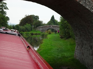
This is our third Narrowboat trip, My sister and her husband have done five, and our new friends have gone twice. As you pilot the Narrowboat through the UK’s canal system, bridges are a constant. There is a bridge every mile or so. Sometimes you have to actually pilot the boat across a bridge over a valley, but normally we are navigating the boat under the bridges. Now these bridges are very useful in navigating, because they are all numbered and you can track your progress and locate your position in the guide book by knowing which bridge you just went under. There are railway bridges, and motorway bridges, but the majority of the bridges crossing the canal are just bridges. They go nowhere; there is nothing on either end. Perhaps 100 years ago there was a cart road, but now there is just a field on either end of the bridge. We saw more cows on bridges than vehicles. And most of these bridges are old; crumbling brick structures arching across the canal no where near a road.

Now the boats are called “Narrowboats”, because the canals are narrow so the boats are only seven feet wide to allow two boats to pass in opposite direction on the canals. These bridges are even narrower, allowing only one boat to go under at a time. The canal under the bridges narrows to about nine feet, allowing only a foot at the most on either side. To compensate for being “narrow”, the boats are long, and with six people this year our boat is almost 70 feet long. For some reason, the bridges always seem to be positioned on a corner, so you are cruising along and you come around a corner to find a bridge in the middle of the corner. It is not easy to get a 70 foot long boat lined up to slip under a bridge that is only slightly wider than the boat. All the bridges sport scars from boats not being perfectly aligned and to see some of the scars, you have to wonder what the boats that made them look like. Sometimes you carefully get you boat all lined up to slip through and OOPS, there is another boat coming down who has the right-of-way and you have so quickly change course to let him through.
Two bridges in a row

But on our first day, we managed to successfully navigate three lift bridges, and under 45 regular bridges. We did run aground while trying to avoid a traffic jam at one bridge and we scared one of our crew who suddenly looked up to see the boat headed right into the side of a bridge (It was one that required a bit of a “tack” on a very sharp turn, and we actually made it through perfectly). Tomorrow we have two tunnels and two aqueducts to navigate, so there is always something to keep you entertained.

Wednesday, April 5, 2017

Wind on the Gulf


Visiting Debbie
Today we drove to Gulfport to visit an old friend. I taught her son in grade one when she helped me rescue a Christmas Concert, and Regis has book club with her.

Although it was a HOT 33° at one point, there was a strong wind blowing in off the Gulf, so it made for a pleasant day. After visiting and going out for a lunch on the waterfront, we headed back to Lakeland via the Sunshine Skyway Bridge. The last time we crossed this beautiful bridge it was to discover everyone in St Petersburg wearing wool hats and gloves when we came for a few “Beach Days” during March Break many years ago. Needless to say we did not spend much time on the beach that year.

Today as we crossed the causeway leading to the bridge we noticed a large group of Para
A good Day for sailing
surfers enjoying the windy day. We found a convenient access road to the beach and we were able to stop and watch them up close. It was really interesting. They would stand in the water’s edge with their kite high above them, and when they found a free area of water, they swung the kite and took off across the water out into the Gulf. Some of them allowed the kite to lift them high into the air where they spun and then came back down, skimming the waves.

One of the most amazing kite surfers we were told was a 14 year old, but Regis did wonder why he wasn’t in school (Once and Vice Principal – always a vice Principal).


Monday, October 6, 2014

Sailing Into Budapest


Sailing by Margaret Island
Arriving in Budapest, Hungary at the culmination of the river cruise was quite the experience. The ship’s program director obviously knew how to arrange this event. It was announced that we would not be arriving in the city until late on Friday evening so that we could experience the city all lit up for us. What a let down when the evening after the boat left, we found that looking out the apartment window, the city just as brilliant; they had not actually done it just for us . . . .?

Castle Hill and Royal Palace
Regis is usually so polite she does not like to take “front-row” seats because then we block other’s views, but tonight she was happy to go up on the top deck early and grab the best seats right in the front. Now she did set up the entire two front rows for anyone else that wanted a good seat, and I went for blankets for everyone as well (it is October and getting cool even in Hungary).

Parliament Buildings 
The captain obviously knew what he was doing, because he was going unusually slowly all afternoon, ensuring we would arrive at the best time. Sitting in deck chairs wrapped in blankets we watched the black Danube glide by as we waited for the city to appear. Finally after one false sighting – just a highway bridge, we rounded a bend and could see the city glowing in the distance. As we drew closer it grew in brilliance. Budapest has four major bridges spanning the Danube at its core, and these are all illuminated. Each bridge is different. First is the Margaret Bridge, a modern looking span, although over a hundred years old, followed by the Chain Bridge, an old historical stone and steel structure built in 1849. Next is the Elizabeth Bridge, a bit of a boring modern one, and finally in the distance is the Liberty Bridge, built in 1896. It is nice to know that even though some of these bridges have been destroyed in wartime, they were rebuilt rather than replaced.

Chain Bridge
The Parliament Buildings
Although we could not help but focus on the bridges as we were sailing under them, the really spectacular sights were on either side, the huge Parliament building styled after the British Houses of Parliament, built right on the bank of the Danube, and the Royal Palace perched on the opposite hilltop on the Buda side. These and most other major buildings are fully illuminated by flood-lamps, making them glow like golden monuments, and off in the distance like the statue in Rio is the huge statue of the Liberty monument glowing on the hilltop. In between were the various Cathedrals, churches and Synagogues, each trying to outdo the others.

It really was a beautiful sight, and sailing into the city on the grey Danube (The waltz “Blue Danube” was obviously written before pollution), but really the pictures show it so much better than my description.


Wednesday, July 6, 2011

Bridge Out!

If you read the previous entry called "Off the Beaten Path", you know that we ran into (well not literally) a detour around a bridge that was absent. Yesterday we found another.

We were aiming for Columbus Ohio to visit some friends from our last cruise, Herbie & Rosalie. We had found a campground, but it was 30 min. Outside of Columbus. There was another closer, but the reviews were of the "worse campground ever!" variety, so we took the 30 min. Drive over the "fecal matter in the showers".

We knew about where we were going, and Regis had our route pretty well planned, but the GPSs were very confused. We arrived at an intersection with a little green picture of a trailer (usually indicating a campground), and an arrow pointing left. One GPS wanted us to go that way. Regis' route said we should have gone right, and the other GPS said to turn right. We have come to trust Regis' navigational skills, and the GPS that agreed with her had the updated maps, so we went right.

Three more turns through lovely rural Ohio countryside, but no signs for the campground.

Then the GPS wanted us to turn onto a road "Closed to all but local traffic". The GPS said the road to our "destination" was in 800 m, and the sign said the road was closed in 1000 yards. Ok, now how does the metric to imperial work? Was our next turn just before the construction or just after?

Oops I missed that sign!
We decided that the turn we needed was probably just this side of the construction, and started down the road - got to a barrier across the road before the road to the campground. No room to turn either.

I got out and walked up to see the construction. Yup, another bridge completely gone. There was the road we needed; just beyond the construction.

Back at the truck, I surveyed the surroundings. No room on road to turn 50 feet of truck & trailer, but the house beside us had a circular driveway. I took off my "gangster" sunglasses, and knocked at the door. After a few minutes, a lady came to the door, and I asked about the campground - sure enough, it was just a bit down the road we could see but couldn't reach. She did give me directions to get there however, and then I asked for permission to turn in her drive.

Autumn Lakes Campground
Her directions were good, and we got to the campground. The campground manager was glad to see us, for she had received my e-mail inquiries late and thought we probably went elsewhere. When I commented on the closed road, bridge out, and GPS confusion, guess what she said - "You can't rely on those stupid things in rural Ohio; here's how the locals get here.